From Washington to you
Copalis Ghost Forest
Copalis River ghost forest · Grays Harbor County · January 26, 1700
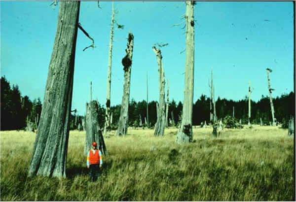
Western red cedars at the Copalis River died between the 1699 and 1700 growing seasons — killed when Cascadia dropped the coast.
A dead forest of western red cedar stands in a brackish tidal marsh on the Copalis River. USGS says the trees were killed by rapid subsidence during the most recent Cascadia megathrust earthquake. Tree rings show they died sometime after the end of the A.D. 1699 growing season and before the beginning of the A.D. 1700 growing season.
That timing matches a tsunami recorded in Japanese historical records. USGS Fact Sheet 2025-3050 dates the last great Cascadia earthquake to January 26, 1700, with an estimated magnitude between 8.7 and 9.2. Living forest behind the snags stands above the highest tides.
The photograph below is by Brian Atwater of the U.S. Geological Survey. The sources below are USGS pages.
- Geography & Geology
- Science / Strange Washington
Sources (2)
government · Tier S
U.S. Geological SurveyDead Red Cedar Forest
government · Tier S
U.S. Geological SurveyEarthquake probabilities and hazards in the U.S. Pacific Northwest
Last reviewed: September 21, 2026
Keep wandering
same arc
2001 Nisqually EarthquakeA deep magnitude 6.8 shock under Puget Sound injured about 400 people and forced a disaster declaration covering 24 counties.
same arc
Cascadia Subduction ZoneA quiet plate boundary runs from California to British Columbia — and under Washington.
nearby
Grays Harbor National Wildlife RefugeTwo percent of Grays Harbor's intertidal flats can hold up to half the harbor's spring shorebirds, especially western sandpipers and dunlin.
nearby
Olympic Coast National Marine SanctuaryNOAA designated 3,188 square miles of ocean off the Olympic Peninsula on July 22, 1994, from the beaches out across the continental shelf.